Author: Zhang Shouzhen, the Emeritus Professor of National Kaohsiung Normal University and Wenzao Ursuline University of Languages.
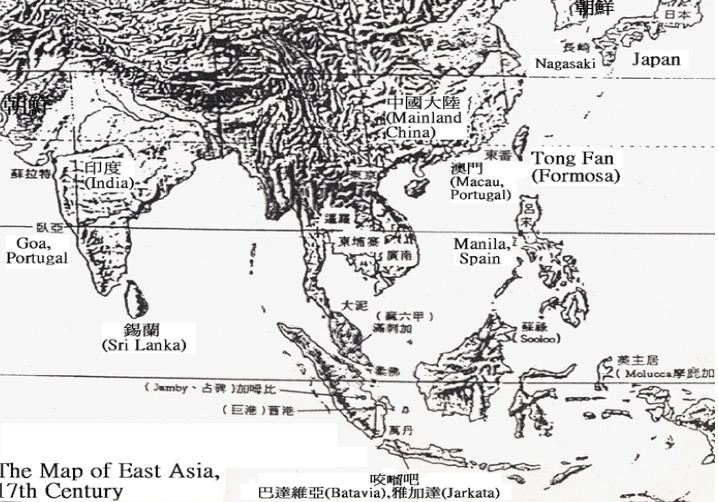
The 17th-century East Asian map included North Korea, Japan, and China, which was under the rule of the late Ming dynasty. Macau, a Portuguese colony, and Formosa, the Dutch name for Taiwan, were featured on the map. Manila, the capital of the Spanish Philippines (Las Islas Filipinas), was another notable inclusion. In 1619, Jakarta, then known as Batavia, was established as the capital of the Dutch East Indies. The Malacca Sultanate, a powerful kingdom in the Malay Peninsula, was also shown on the map. Vietnam, Siam (now Thailand), and Ceylon (Dutch colonization (1656-1796); British colonization (1796-1948); known as Republic of Sri Lanka since 1972) were other noteworthy regions depicted on the map. Goa, a Portuguese colony in India, completed the diverse picture of 17th-century East Asia.
1. In East Asia, the location of Taiwan plays a pivotal role in terms of sea-air transport freight from a strategic perspective.
2. The historical villa Xiaoyao Garden in Kaohsiung was once owned by Otani Kozui, the 22nd patriarch of the Nishi Hongan-ji. Otani Kozui described Taiwan as a "jewel" of the Japanese empire. “The city view of Kaohsiung is the highest function of any transit harbor in Taiwan. Additionally, the land use of the heavy and light industries in Taiwan serves the best in all Japanese territories.” Otani stated.
In January 1603 (December, year 30 in the reign of Wanli Emperor of the Ming Dynasty), You-Rong Shen, the commander of the Wu-yu Navy Base (now Kinmen) successfully expelled Japanese pirates (Chinese: 倭寇; pinyin: wō kòu) from the east shore of Taiwan, later berthing at Dayuan (now Anping). Di Chen, the Ming philologist from Lienchiang accompanied Shen described in his work Dōng Fān Jì (東番記) in the spring of 1604 (year 32 in the reign of Wanli Emperor):
“The exact time of the arrival of the barbarian (Pepohoan) in Dong Fan (now Taiwan) is lost to history, but they have made the outer sea islands of Penghu their home for centuries. The coastal living areas include Wang Gang (now Port of Budai; Dutch: Wankan), Jia Lao Wan (Now Tu Cheng Zi in Annan District, Tainan), Da yuan (now Anping; Dutch: Taoyuan), Yao Gang (now Qieding District, Kaohsiung), Takao Yu (now Cihou, Qijin; Dutch: Tankoya), Xiao Tamsui (now Gaoping River), Shuang Xikou (now Puzi Estuary, Chiayi), Jia Li Lin (Erlin, Changhua), Sha Ba Li (Tamsui District, New Taipei City), Da Bang Keng (now Da Ben Keng of Bali District, New Taipei City).”
“Originally, all Pepohoan resided in villages along the coast of Taiwan. During the waning years of the Jiajing Emperor's reign, they were ravaged by Japanese pirates and compelled to seek refuge in the mountains." “After settling down in the mountains, the Pepohoan people began to trade with Chinese merchants from Zhang and Quan. The merchants from Chonglong (Chonglongshe, Tong'an County, Quan Zhou Prefecture), and Lieyu (now Little Kinmen) often translated for the Pepohoan and traded goods such as agate, porcelain, cloth, salt, copper hairpins, and rings for deer jerky, skins, and antlers.”
Xie Zhang (Chinese: 張燮; pinyin: Xiè Zhāng) was the author of Investigations on the East and West Seas (Chinese: 東西洋考; pinyin: Dōng Xī Yáng Kǎo) which recorded all major ports in east Taiwan with “the needle route” (a sailing route with the assistance of a compass needle) in 1617 (year 45 in the reign of Wanli Emperor).
“Dong Fan (the east side of Taiwan) was known as Little Dong Yang. Starting from Penghu, it took a day and a night to sail to Wang Gang (now Port of Budai)”, and another day to sail to Takao (now Cihou and Qijin; Dutch: Tankoya). Upon arrival, the ship voyaged to Jiao Li Lin (Now Erlin, Changhua) and headed southeast with the guide of compass needles named Chen and Xun at 3 AM. Then, the ship sailed to Quelang/Kelang (now Keelung and Tamsui).
With all the information provided, it is known that ports along the western coast of Taiwan, such as Takao (now Cihou and Qijin), Wang Gang (now Port of Budai), Jiao Li Lin (now Erlin, Changhua), Quelang/Kelang (now Keelung and Tamsui), became pivotal ports on the Chinese maritime route to East Asia by the early 17th century.
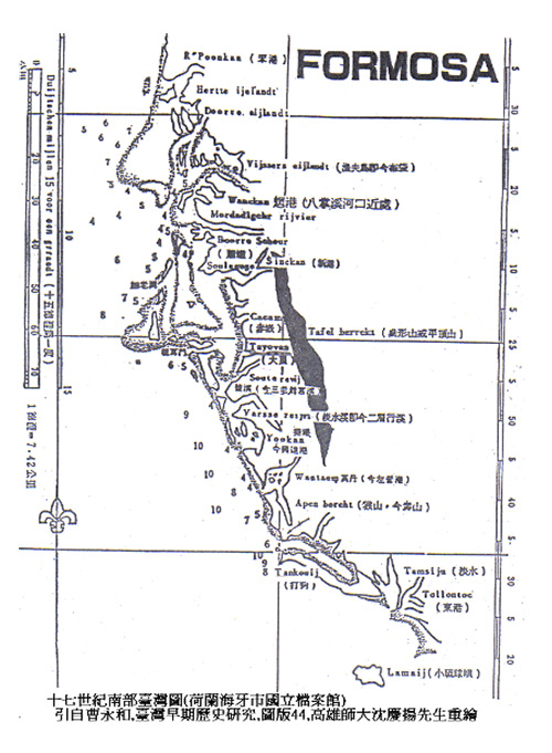
The villages of Tankoya (now Cihou and Qijin) and Apen bercht (now Apen Hill, Monkey Mountain, Shoushan) were already formed in Formosa (Taiwan) during the Dutch Formosa era (1624 to 1662).
In 1624, the Dutch occupied Da Yuan (now Anping District, Tainan; Dutch: Tayouan).
(1) “From January 14 to 15, 1633: 21 fishing junks sailed to offshore China. In the afternoon, 18 fishing junks returned from the south, carrying about 15,000 flathead grey mullets. Upon their return, the Takao Junk immediately sailed south to escort the remaining ships.”
(2) Almost every week after 1643, junks from Da Yuan (now Fort Zeelandia; Dutch: Tayouan) sailed to Takao (now Cihou and Qijin) and carried back firewood.
Resources: The Dutch on Formosa 熱蘭遮城日誌 (Vols.2-4), tr. Chiang Shu-sheng 江樹生, Tainan City Government, (1999), (2002-2007).
1. In Siraya, Ino Kanori, the Japanese scholar believed Takau/Tankoya represented a “bamboo forest.”
2. In Makatto, Ino interpreted Takau/Tankoya as “hanhouse.”
3. Jiayin Weng, the research fellow in Academia Sinica believed the pronunciation of Takao/Tankoya in Dutch was similar to “drumming” in Hokkien, presenting the idea of “The place where the waves splashed against the shore, making a loud sound”.
Published by the Economic Research Department of the Bank of Taiwan, the Fengshan County District Records written by Wen-Da Chen in 1719 (in the reign of Kangxi Emperor) stated on page 5:
“Gushan, a town on the coast that was once home to aboriginals, also known as Da Gou Shan in the past, housed a major naval base till this day. After Dao-Qian Lin was stationed in the mountains, he decided to desert from the military, committing a brutal massacre of the aboriginals and using their blood to build ships for his escape. The aboriginals were forced to flee, seeking refuge in A Hou She.”
“Snake Mountain, historically known as Shou Shan, is fittingly named for its serpentine shape, elegantly sloping away from Da Gu Shan. Situated to the right of Fengshan County, this distinct geological feature forms a striking landscape. Lying on both sides of Da Gu Shan, the islets of Shih-fo and Liang-san are nestled amidst the ocean, standing apart yet cradled by the rhythmic embrace of the waves. In addition, the Shih-fo islet is named after the shape of Buddha. When the ship sailed by the islet, seafarers would be engaged in rituals for good fortune by playing drums and spreading papers.”
“Extending southeastward, the mountain's contour strikingly resembles a soaring phoenix, giving rise to its name, Fengshan, or Phoenix Mountain. To the northeast of Fengshan, a collection of smaller hills dot the landscape, their forms reminiscent of phoenix eggs nestled amidst the terrain. This scenic arrangement is not just a natural wonder but also holds cultural significance, especially for the Confucius Temple in Fengshan, which regards these hills as auspicious supporting elements in Fengshui, enhancing the spiritual and historical essence of the area. The remaining hills, representing the phoenix's nose, on the southwestern side of Fengshan, form a harmonious ensemble that surrounds the town center, adding an auspicious dimension to its Fengshui.”
Located southwest of Da Gu Shan is Cihou Mountain, a low-lying mountain that borders the sea, which is a fishing area for fishermen.