The History of Taiwan and Kaohsiung
文/高雄師範大學 、文藻外語大學 退休教授 張守真
Author: Zhang Shouzhen, the Emeritus Professor of National Kaohsiung Normal University and Wenzao Ursuline University of Languages.
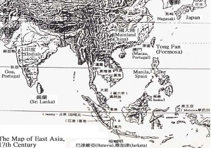
17世紀的東亞地圖:朝鮮、日本 、明末中國 、 澳門(Macau, Portugal)、東番(Formosa)、呂宋(Manila, Spain,菲律賓( 1543,Las Islas Filipinas in honor of Philip II of Spain)、1619年荷蘭東印度公司於雅加達(Jakarta),設巴達維亞(Batavia)總部、麻六甲蘇丹國(Malacca Sultanate, Portugal )、越南 、暹邏(今泰國)、錫蘭 (1656-1796荷蘭;1796-1948英國,1972稱Sri Lanka)、 臥亞(Goa, Portugal)
The 17th-century East Asian map included North Korea, Japan, and China, which was under the rule of the late Ming dynasty. Macau, a Portuguese colony, and Formosa, the Dutch name for Taiwan, were featured on the map. Manila, the capital of the Spanish Philippines (Las Islas Filipinas), was another notable inclusion. In 1619, Jakarta, then known as Batavia, was established as the capital of the Dutch East Indies. The Malacca Sultanate, a powerful kingdom in the Malay Peninsula, was also shown on the map. Vietnam, Siam (now Thailand), and Ceylon (Dutch colonization (1656-1796); British colonization (1796-1948); known as Republic of Sri Lanka since 1972) were other noteworthy regions depicted on the map. Goa, a Portuguese colony in India, completed the diverse picture of 17th-century East Asia.
1.從海空交通運輸、戰略地位來看,臺灣位於東亞的核心地位,可見其重要性。
1. In East Asia, the location of Taiwan plays a pivotal role in terms of sea-air transport freight from a strategic perspective.
2.高雄「逍遙園」主人,西本願第22代教主大谷光瑞稱:「臺灣是日本帝國的如意寶珠。」「高雄於都市勝景為臺灣第一;港灣的機能是中繼港第一名,重輕工業地屬我(日本)領土中第一流。」
2. The historical villa Xiaoyao Garden in Kaohsiung was once owned by Otani Kozui, the 22nd patriarch of the Nishi Hongan-ji. Otani Kozui described Taiwan as a "jewel" of the Japanese empire. “The city view of Kaohsiung is the highest function of any transit harbor in Taiwan. Additionally, the land use of the heavy and light industries in Taiwan serves the best in all Japanese territories.” Otani stated.
1603年1月(明萬曆30年12月),浯嶼(今金門)營將沈有容前來臺灣西部沿岸,追剿倭寇(日本海盜) ,倭破,收泊於大員(今安平)。連江陳第隨行,1604年(萬曆32年)春,歸著《東番記》稱:「東番(今臺灣)夷人(平埔族)不知所自始,居澎湖外洋海島中;起魍港(荷蘭語:Wankan,今布袋港) 、加老灣(今臺南安南區土城子),歷大員(Tayouan,今安平)、堯港(高雄市茄萣區)、打狗嶼(荷蘭語:Tankoya,今旗後,旗津)、小淡水(今高屏溪)、雙溪口(嘉義朴子溪口)、加哩林(彰化二林) 、沙巴里(新北市淡水區) 、大幫坑(大坌坑,新北市八里區),皆其居也。」
In January 1603 (December, year 30 in the reign of Wanli Emperor of the Ming Dynasty), You-Rong Shen, the commander of the Wu-yu Navy Base (now Kinmen) successfully expelled Japanese pirates (Chinese: 倭寇; pinyin: wō kòu) from the east shore of Taiwan, later berthing at Dayuan (now Anping). Di Chen, the Ming philologist from Lienchiang accompanied Shen described in his work Dōng Fān Jì (東番記) in the spring of 1604 (year 32 in the reign of Wanli Emperor):
“The exact time of the arrival of the barbarian (Pepohoan) in Dong Fan (now Taiwan) is lost to history, but they have made the outer sea islands of Penghu their home for centuries. The coastal living areas include Wang Gang (now Port of Budai; Dutch: Wankan), Jia Lao Wan (Now Tu Cheng Zi in Annan District, Tainan), Da yuan (now Anping; Dutch: Taoyuan), Yao Gang (now Qieding District, Kaohsiung), Takao Yu (now Cihou, Qijin; Dutch: Tankoya), Xiao Tamsui (now Gaoping River), Shuang Xikou (now Puzi Estuary, Chiayi), Jia Li Lin (Erlin, Changhua), Sha Ba Li (Tamsui District, New Taipei City), Da Bang Keng (now Da Ben Keng of Bali District, New Taipei City).”
「始皆聚居海濱,嘉靖末,遭倭焚掠,迺避居山。」「居山後,始通中國,今則日盛。漳、泉之惠民,充龍(泉州府同安縣充龍社)、烈嶼(今小金門)諸澳,往往譯其語,與貿易,以瑪瑙、磁器、布、鹽、銅簪、環之類,易其鹿脯、皮、角。」
“Originally, all Pepohoan resided in villages along the coast of Taiwan. During the waning years of the Jiajing Emperor's reign, they were ravaged by Japanese pirates and compelled to seek refuge in the mountains." “After settling down in the mountains, the Pepohoan people began to trade with Chinese merchants from Zhang and Quan. The merchants from Chonglong (Chonglongshe, Tong'an County, Quan Zhou Prefecture), and Lieyu (now Little Kinmen) often translated for the Pepohoan and traded goods such as agate, porcelain, cloth, salt, copper hairpins, and rings for deer jerky, skins, and antlers.”
1617年(萬曆45年),張燮,《東西洋考》載臺灣西部航海「針路」(航線)各重要港口:
Xie Zhang (Chinese: 張燮; pinyin: Xiè Zhāng) was the author of Investigations on the East and West Seas (Chinese: 東西洋考; pinyin: Dōng Xī Yáng Kǎo) which recorded all major ports in east Taiwan with “the needle route” (a sailing route with the assistance of a compass needle) in 1617 (year 45 in the reign of Wanli Emperor).
「東番,人稱小東洋,從澎湖一日夜至魍港(荷蘭語:Wankan,今布袋港) ,又一日夜至打狗仔(荷蘭語:Tankoya,今旗後,旗津) ;又用辰巽針,十五更,取交里林(彰化二林 ),以達雞籠(Kelang 或 Quelang,今基隆) 、淡水。」
“Dong Fan (the east side of Taiwan) was known as Little Dong Yang. Starting from Penghu, it took a day and a night to sail to Wang Gang (now Port of Budai)”, and another day to sail to Takao (now Cihou and Qijin; Dutch: Tankoya). Upon arrival, the ship voyaged to Jiao Li Lin (Now Erlin, Changhua) and headed southeast with the guide of compass needles named Chen and Xun at 3 AM. Then, the ship sailed to Quelang/Kelang (now Keelung and Tamsui).
可知臺灣西部沿岸的港澳如打狗、魍港、交里林、雞籠、淡水等地,於17世紀初葉,已成為漢人東洋航線上重要的港口。
With all the information provided, it is known that ports along the western coast of Taiwan, such as Takao (now Cihou and Qijin), Wang Gang (now Port of Budai), Jiao Li Lin (now Erlin, Changhua), Quelang/Kelang (now Keelung and Tamsui), became pivotal ports on the Chinese maritime route to East Asia by the early 17th century.
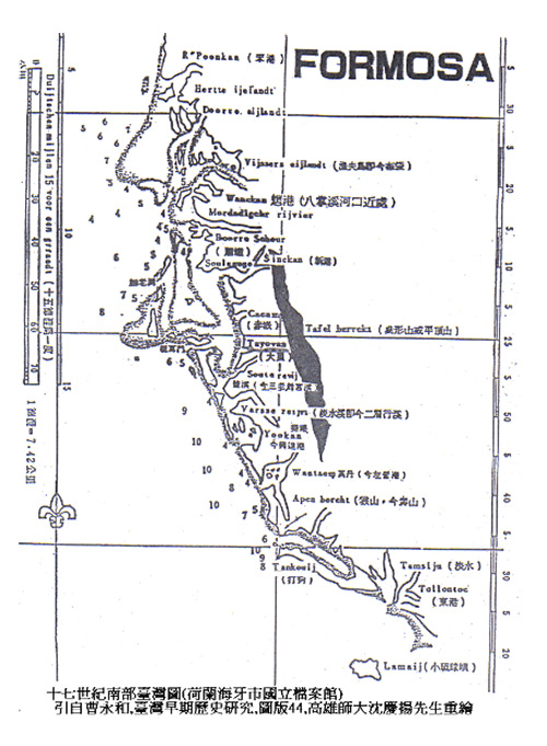
荷蘭時代(1624-1662),Formosa 已可見 Tankoya (打狗仔,旗後),Apen bercht(Apen Hill,猿山,壽山)The villages of Tankoya (now Cihou and Qijin) and Apen bercht (now Apen Hill, Monkey Mountain, Shoushan) were already formed in Formosa (Taiwan) during the Dutch Formosa era (1624 to 1662).
從荷蘭於1624年,進佔大員(Tayouan,今臺南安平),
In 1624, the Dutch occupied Da Yuan (now Anping District, Tainan; Dutch: Tayouan).
(1)「1633年1月14日-15日:有二十一艘漁夫的戎克船出航前往中國沿海,下午有十八艘漁夫的戎克船從南部來,載來約一萬五千條烏魚,戎克船打狗號護送他們回來以後,立刻又去南部,要去護送剩下的漁夫的戎克船。」
(1) “From January 14 to 15, 1633: 21 fishing junks sailed to offshore China. In the afternoon, 18 fishing junks returned from the south, carrying about 15,000 flathead grey mullets. Upon their return, the Takao Junk immediately sailed south to escort the remaining ships.”
(2)1643年開始,幾乎每周都有大員(Tayouan,今熱蘭遮城)的戎克船,前往打狗(Tankoya,今旗後)運載著柴薪。
(2) Almost every week after 1643, junks from Da Yuan (now Fort Zeelandia; Dutch: Tayouan) sailed to Takao (now Cihou and Qijin) and carried back firewood.
資料來源: 江樹生譯,《熱蘭遮城日誌》,第二冊至第四冊, 臺南市政府,1999年,2002年至2007年。 Resources: The Dutch on Formosa 熱蘭遮城日誌 (Vols.2-4), tr. Chiang Shu-sheng 江樹生, Tainan City Government, (1999), (2002-2007).
打狗仔(Takau,Tankoya)地名由來:
The origin of Takao (Dutch: Takau/Tankoya):
1. 伊能嘉矩從西拉雅族語解讀,認為是「竹林」的意思。
1. In Siraya, Ino Kanori, the Japanese scholar believed Takau/Tankoya represented a “bamboo forest.”
2. 另從馬卡道族語解讀,認為是「雞社」的意思。
2. In Makatto, Ino interpreted Takau/Tankoya as “hanhouse.”
3. 翁佳音(中研院)從荷蘭語Tankoya(Takau,打狗仔)其發音類似「銅(打)鼓仔」 ,認為是「海浪拍岸,聲音響亮的地方」的意思。
3. Jiayin Weng, the research fellow in Academia Sinica believed the pronunciation of Takao/Tankoya in Dutch was similar to “drumming” in Hokkien, presenting the idea of “The place where the waves splashed against the shore, making a loud sound”.
陳文達,〈山川〉,《鳳山縣志》,臺灣銀行經濟研究室,1719年(康熙58年),頁5載:
Published by the Economic Research Department of the Bank of Taiwan, the Fengshan County District Records written by Wen-Da Chen in 1719 (in the reign of Kangxi Emperor) stated on page 5:
「於大海之濱者,曰打鼓山(俗呼為打狗山,原有番居焉。至林道乾屯兵此山,欲遁去,殺土番取膏血以造舟;番逃,而徙居於今之阿猴社);水師之營壘在焉。」
“Gushan, a town on the coast that was once home to aboriginals, also known as Da Gou Shan in the past, housed a major naval base till this day. After Dao-Qian Lin was stationed in the mountains, he decided to desert from the military, committing a brutal massacre of the aboriginals and using their blood to build ships for his escape. The aboriginals were forced to flee, seeking refuge in A Hou She.”
「從打鼓山蜿蜒而下,勢若長蛇,為蛇山:是邑治之右肩也。隔海參差、遠近浮沉而列於打鼓山之左右者,西有石佛(大石屹立於海中,形似佛,故名。舟經此,鳴金鼓以獻紙)。」
“Snake Mountain, historically known as Shou Shan, is fittingly named for its serpentine shape, elegantly sloping away from Da Gu Shan. Situated to the right of Fengshan County, this distinct geological feature forms a striking landscape. Lying on both sides of Da Gu Shan, the islets of Shih-fo and Liang-san are nestled amidst the ocean, standing apart yet cradled by the rhythmic embrace of the waves. In addition, the Shih-fo islet is named after the shape of Buddha. When the ship sailed by the islet, seafarers would be engaged in rituals for good fortune by playing drums and spreading papers.”
「有橫列於東南形似飛鳳,曰鳳山。又有數小峰圓淨豐滿,錯落於鳳山之東北者,曰鳳彈(形似卵,俗呼為鳳卵;文廟視此為案山)。其在西南而與鳳山相附者,曰鳳鼻(有小崙形似鼻,故名):悉皆環拱於邑治之前,而為邑之對山也。」
“Extending southeastward, the mountain's contour strikingly resembles a soaring phoenix, giving rise to its name, Fengshan, or Phoenix Mountain. To the northeast of Fengshan, a collection of smaller hills dot the landscape, their forms reminiscent of phoenix eggs nestled amidst the terrain. This scenic arrangement is not just a natural wonder but also holds cultural significance, especially for the Confucius Temple in Fengshan, which regards these hills as auspicious supporting elements in Fengshui, enhancing the spiritual and historical essence of the area. The remaining hills, representing the phoenix's nose, on the southwestern side of Fengshan, form a harmonious ensemble that surrounds the town center, adding an auspicious dimension to its Fengshui.”
「其在打鼓山之西南,曰旗後山(山不甚高,臨於海邊);為漁人採捕之區也。」
Located southwest of Da Gu Shan is Cihou Mountain, a low-lying mountain that borders the sea, which is a fishing area for fishermen.